You may view these photos as a slide show or an indexed list. There is also a trip map (BIG, 1,100K!). On a related note, you might be interested in checking out my 1982 Three Passes Trip photos, which includes some of this same area.
This trip was a Sierra Club outing, sponsored by the Mother Lode Chapter. Alan Mendoza, from Chico, was our trip leader. I contacted Alan, to invite him on my 2001 Wishon-Portal trip. He declined, but countered with an offer to join his group on this trip. It sounded too good to pass up, even if the trip description sounded a bit daunting.
We met at Karl's house in Grass Valley. The three of us hopped in my van and drove to Reno, where we picked up Lisa at the REI parking lot. From there, we journeyed to the Mono Lake Visitor's Center, to a rendezvous with Rod. We then drove up to the Pine Creek Trailhead, where we left Rod's crew cab, as our end-of-trip shuttle vehicle. After a decent Mexican dinner in Bishop, we drove to the old Trail Permit station on Highway 168 in the Buttermilk Country, where we car camped in the sandy, high desert.
The next morning, in bright sunshine, we drove my van up to North Lake Trailhead, and began hiking. Thus began a steady, relentless ascent to Piute Pass. We ran into a lot of fellow hikers, including a number of ultra-fit trail runners. Rod, inventor of the PackShade backpack shade attachment, handed out business cards to anyone who expressed interest in his unique product.
We took a break at Piute Pass and refilled our water containers at Summit Lake. This proved to be a fortunate step, as we soon learned that the countryside was very dry, and that water was found in only in established lakes and the largest creeks. That afternoon, we ambled around the Humphreys Basin a bit and made our way to Lower Golden Trout Lake.
My pack on this trip was lighter than it had been on previous trips, but it was substantially heavier than my companions' packs. The main difference was in food, and in some extra clothing. My food cache weighed 15 lbs, with the total pack weight about 65 lbs (including water). This weight proved to be a bit of a challenge during the trip.
I had a Bearikade lightweight composite bear-resistant food container, and thus did not need to worry much about food storage. My companions did not have such a device, and were a bit concerned the first night out, as we'd heard that the Golden Trout Lake area had experienced some bear raids. The group bundled all their food together and fabricated a noise alarm system out of pots and pans. Everyone went to sleep, and was later rudely awakened by a crash of metal, and Rod shouting, "Bad Bear! Bad Bear!" The ferocious bear turned out to be a pika. Rod decided to take all the food into his tent, where it resided safely until morning.
That night, I also realized that my toothbrush was left in the van. I got into some intense flossing during the rest of the trip, and resorted to washing my teeth with a paper towel, after a couple of days. Karl considered sawing his toothbrush lengthwise and giving me half, but happily it didn't come to that.
The next day, we headed down Piute Canyon, toward the junction with the French Canyon Trail. I was not feeling too good, and began to express the possibility of taking an easier route for my own version of the trip. Alan was supportive, if that was my decision. Rod even offered to go with me. I was very grateful, and decided to hang in there for a while. My pack was a bit heavier than everyone else's, and the other hikers each insisted on relieving me of various articles, to help ease the load.
We made our way up French Canyon, and then turned up the steep route to Merriam Lake. We could see a few footprints along the way, but it seemed that we had left the crowds behind and that we would now have solitude. That turned out to not be the case, as we reached the lake. A group of about a dozen hikers was camping at the lake, members of a Sierra Club National Trip, following essentially the same route we were, but a day or two ahead. We chatted briefly with the other group and then made our own camp a bit further up the lakeshore. We all took the opportunity to soak our feet in the water, and do a little washing.
We camped at Merriam Lake for two nights. On the layover day, Karl and Lisa climbed Merriam Peak, while Alan explored the Merriam Lake Basin, all the way to La Salle Lake. Rod and I hung around the campsite and rested for the climb over Feather Pass.
On the fourth day, we all headed up to Feather Pass, following Alan's suggestion that we take a slightly higher contouring route, rather than staying in the bottom of the drainage. This turned out to be a great idea, as we took advantage of relatively smooth slabs, rather than stumbing over rougher boulders and dry water courses. The scenery opened up before us, as we reached the pass. We took the usual obligatory group photo, as we took a break.
The terrain heading down the other side of the pass was a bit rougher, with some loose sand and talus. We made our way down the basin, toward Bearpaw Lake. As we reached the meadow by the lake, there was a momentary panic, as Lisa realized she had left her camera back up the hill, on a potty break. Luckily, she was able to remember the exact location, and soon recovered her camera. Then, a few minutes later, we ran into a pair of technical climbers, who happened to be Lisa's good friends. We chatted with them briefly, and then made our way over the ridges to Vee Lake.
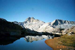
At Vee Lake, there was a brief debate about where we would camp. Some wanted to camp back along Vee Lake, while Rod and I favored an interesting promontory that overlooked the Seven Gables Lakes Basin, with Gemini and Seven Gables Peaks looming above. We set up our camp there, in the various sandy shelves that presented themselves. I liked to think of this as our "castle camp." We decided to layover here for two nights.
The next morning, on the layover day, Lisa and Karl decided to climb Gemini Peak, after chatting with a couple of other Sierra Club peak baggers who passed by our camp the preceding evening. We watched Lisa and Karl make their way up, until we lost them in the rocky background. Alan went off and explored the route to Dancing Bear Pass, that we would later follow. Rod and I spent the day resting and recuperating.
We were treated to spectacular sunsets and moonrises on both nights at Castle Camp. After the second morning there, we packed up and headed up and over the ridges toward Dancing Bear Pass. Gemini and Seven Gables Peaks remained visible for a great while, even as we crossed over several ridges. The scenery was pretty dramatic, as we stepped out into the rough, rocky basin between Dancing Bear Pass and Italy Pass. It was rough but fun making our way through.
At Italy Pass, Karl and Lisa decided to try for Mount Julius Caesar, which loomed above. Rod and Alan and I encouraged them, and stayed for a few minutes to watch. We then struck out down the rough route into Granite Park, toward our last campsite, at Honeymoon Lake. This was a big descent, from our high point at Italy Pass (12,400'). I felt a tinge of sadness, knowing that we had been through the best areas on our trip. Luckily, the remaining portion wasn't all that bad. The clouds began to gather as we hiked, and we grew concerned that we'd be rained out. We were especially concerned about Lisa and Karl, who were a couple of hours behind us. Happily, the threat of rain did not materialize, and we arrived at the lake in good shape. We began running into more and more people, and it was apparent that we would be sharing the lake with a lot of others.
We found a somewhat marginal campsite at the lake, and set up our tents. As we ate dinner, we were treated to a show of real-life predator-prey action, as a hawk swooped down and killed a squirrel, just a few feet from Alan's tent. The bird looked at us defiantly, as it began to eat it's prey. It stayed there for quite a while, and we grew concerned that it would leave the carcass in our camp. Luckily for us, it carried the squirrel off, probably back to it's nest, to feed to the kids.
The next morning, we headed back down the trail toward Pine Creek Trailhead. On the way, we passed the beautiful Pine Lakes, with a last view of the Sierra Crest. Our knees took a beating as we dropped the remaining 3,000' to the car. Rod warned us that we would be looking longingly at the parking lot area for quite a while, as we traversed the last switchbacks. Eventually, it all came to an end, as we passed big groups of hikers, with various levels of preparation and experience, heading in the opposite direction to begin their last summer hiking flings over the Labor Day weekend.
This was a great hike. All told, we hiked about 40 miles, with the peak climbers and day hikers travelling quite a bit more. I had a lot of fun with everyone in our group, and appreciated how we all supported each other along the way.
Photo Notes: My camera on this trip was my beat-up but functional Samsung automatic 35mm compact camera. I had been a little bit unhappy with the performance of my Canon AE-1P on the Wishon-Portal trip, and decided to try the Samsung again. I hope you enjoy the pictures! You may view them as a slide show or an indexed list.
Acknowledgements: A special thanks to Rod Java, for encouraging me to try Kodak Photo CDs (used on this project), and in helping underwrite the cost. Check out his business project, PackShade.
Best Regards,
Frank R. Farmer
ffarmer
Copyright © 2001-2020 Frank R. Farmer - All Rights Reserved