You may view these photos as a slide show or an indexed list. There is also a trip map (BIG map, 380K!).
This Trip Report covers a loop trip that Ron Karliner and I completed in the Mineral King region of Sequoia National Park, from September 15-19, 2002. It was a great trip! The weather was very dry, and there were no mosquitos to be found. Bears did not pay us any visits.
Our route began at the Mineral King trailhead, climbing steeply toward Sawtooth Pass. We gravitated into Monarch Creek Canyon, where we camped the first night. We tried to minimize our impact on the canyon, knowing that NPS prefers that hikers stay out of there. We definitely minimized our impact on the overcrowded Monarch Lake Campground!
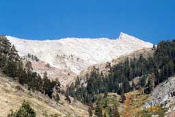
The next morning, we continued the steep, messy climb to Sawtooth Pass, and proceeded east and down to Columbine Lake. It was remarkable to encounter the huge cairns on the trail to the lake, after stumbing up the confusing Sawtooth Pass "Trail."
Our second night's camp was in Lost Canyon. The next day, we stopped to look at a NPS helicopter take off near the Soda Creek Trail junction, before climbing north and west around a big ridge to Big Five Lakes, and on to the third night camp at Little Five Lakes.
The next morning, we climbed steeply over Black Rock Pass, pausing to take pictures and reflect on the view. We met an interesting solo hiker, and traded information about water availability and trail conditions. We hiked down to our fourth camp, near Pinto Lake. It was very confusing to find Pinto Lake, once we were close to it. We used Ron's digital camera to check an image and locate our position relative to the lake exactly. (I gotta get a GPS!).
We continued down Cliff Creek Canyon on our fifth and last day, to the junction with the Timber Gap Trail. We began the long climb to Timber Gap, stopping to take in a hazy view of Tableland in the distance. After pausing at Timber Gap, we tightened our boots one last time, and proceeded down steeply to the trailhead and the end of another great trip.
TOPO! software (map above) measured the total map distance at 32.6 miles and 10,600 feet elevation gain/loss.
Background Information: Here are additional trip reports from Charles Hayden and Doyle Donehoo.
Photo Notes: The camera on this trip was my Samsung automatic 35mm compact camera. I hope you enjoy the pictures! You may view them as a slide show or an indexed list.
Best Regards,
Frank R. Farmer
ffarmer
Copyright © 2002-2020 Frank R. Farmer - All Rights Reserved